Hurricane Harvey made landfall as a category 4 storm with 130 mph winds around 11:00pm (EDT) on August 25, 2017 between Port Aransas and Port O’Connor. Harvey is the strongest hurricane to impact Texas since 1961 and the first category 4 storm to make landfall in the United States since Hurricane Charley in 2004.
“Estimates place the total damage to the state as high as $180 billion” states the Governor’s Commission to Rebuild Texas, “with tens of thousands of homes, businesses and other property lost and extensive portions of the Gulf Coast economy disrupted for months.”
Households and Properties Affected Statewide
According to the Kinder Institute for Urban Research Analysis, the neighborhood most affected by Harvey was Cypress North followed by Memorial, East Houston, South Belt/Ellington, Kingwood, Baytown, Champions, Bellaire, and Klein East.
The households that suffered the most had an income of less tha $25,000 to $49,999. The flooding also disproportionately impacted white, middle class and upper class communities in the City of Houston.
More renters than homeowners were affected in the City of Houston, however renters (43 percent of units affected) and buyers (46 percent of units affected) alike were equally affected across Harris county.
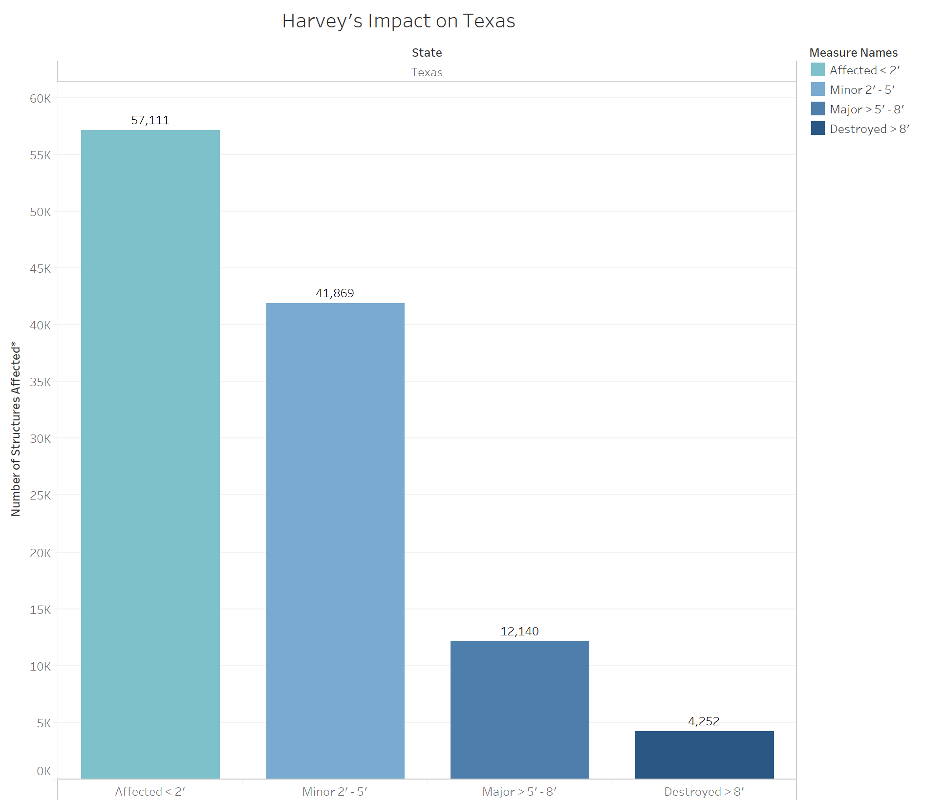
*Note – this does not account for elevated structures and assumed that the parcel centroid is the building location. In addition, this does not account for wind damage, flooding from dam or levee breaks, flooding as a result of failure of irrigation ditches, use of spillways and weirs, small tributary flooding with minimal or no gage data, or stormwater backup. This data will be refined using event imagery, when provided.
As of August 28, 2017, a total of 115,372 structures were impacted in Texas according to FEMA’s Hurricane Harvey Damage Assessments. Total Residential and Manufactured Home Count is significantly higher at 2,175,126 structures depicted above. In total, the number of structures damaged statewide came to 2,466,317.
According to the Governor’s Commission to Rebuild Texas, the storm directly affected more than 60 counties and left a path of damage and destruction along 300 miles of coastline and extended 100 miles inland.
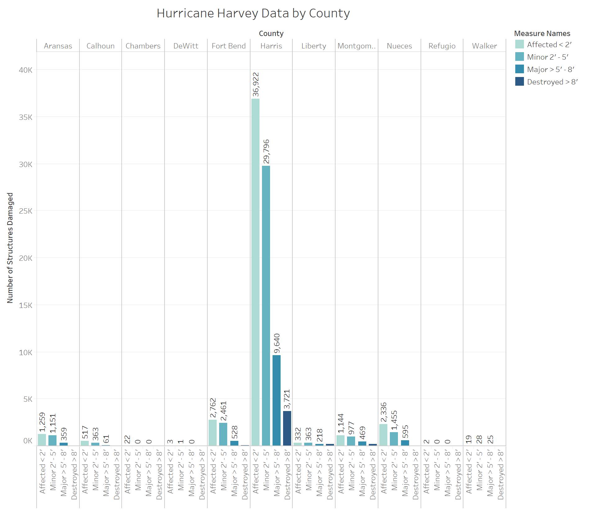
Harris County confronted the most damage with Fort Bend County and Nueces County following closely behind in destruction. In Harris County, a total of 80,079 structures were damaged by Harvey with 36,922 of these structures affected by 2 inches of water or less, 29,796 by 2 to 5 inches, 9,640 by 5 to 8 inches, and 3,721 considered “destroyed” by 8 inches of water or more. The total number of structures damages by Harvey in Harris county alone came to a grand total of 1,305,101 structures.
Storm-Related Deaths
According to the Harris County Institute of Forensic Sciences, there were 36 storm-related deaths as of Sept. 27. The loss of life may actually be greater. According to the Texas Tribune, over 80 people lost their lives.
Rainfall
An average of 51.66 inches of rainfall in Houston. Overall, Harvey released 14-15 trillion gallons of water (as of August 28). This is more than double the amount of water released by Katrina (6.5 trillion gallons.) Most of Harvey’s damage was a result of the heavy rainfall after it reached land.
Environment and Debris
The Texas Department of Transportation collected over 10 million cubic feet of debris in the four districts most impacted by Hurricane Harvey since landfall. This is the equivalent of 186 football fields. Ten of the twenty-five State of Texas Assistance Requests for debris removal received by TxDOT have been completed. Debris removal has been completed in 10 counties and cities.
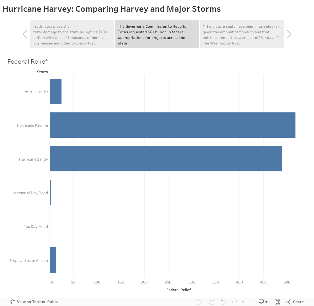
Compared to other Major Storms
Although NOAA has not yet provided figures for the cost of damage, it placed this hurricane on its billion-dollar disaster list for 2017. Time Magazine ranked 2017 as one of the nation’s worst years for storm damage since 1900, ranking it second in terms of damages.