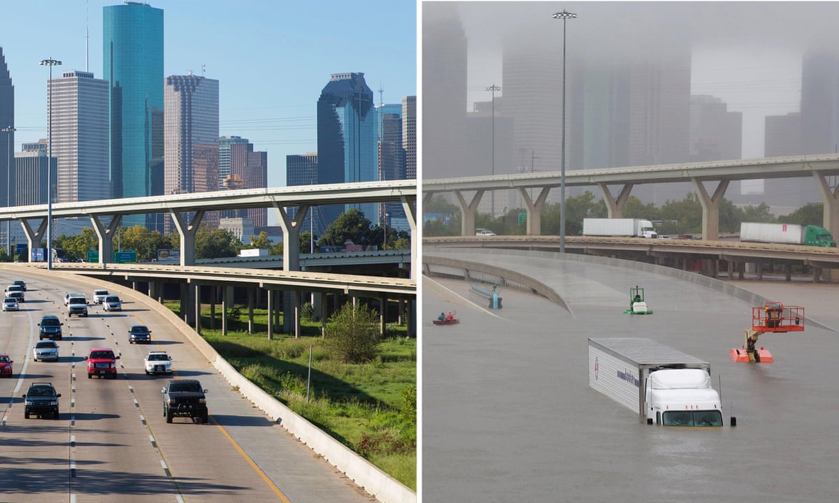
Before and after photos show the impact of flooding in our region (Hurricane Harvey, 2017)
In the wake of increasingly frequent and severe weather events, Greater Houston’s future depends on how effectively we prepare, respond, and adapt. From Hurricane Harvey to more localized but still damaging storms, the cumulative impact of flooding is not just an environmental issue; it is an economic, social, and infrastructural one. As a region that continues to grow at a rapid pace, Greater Houston must address flood risk with the same intentionality and collaboration that fuels its development.
Flood control, at its core, is a public responsibility. But it is also a shared challenge that crosses jurisdictional boundaries, political lines, and geographic divides. Growing a truly resilient region requires us to think beyond the limits of traditional governance, embrace innovative partnerships, and foster a new level of cooperation between cities, counties, utility districts, state agencies, and private sector stakeholders. Fortunately, examples of collaborative success already exist and offer powerful lessons for how we move forward.

Harris County Watersheds go beyond the county line, with everyone downstream feeling these effects. (Click the image to find your watershed!)
Flood risk does not adhere to political boundaries. Watersheds stretch across cities and counties, often involving multiple governing bodies with different mandates, resources, and constituencies. In this context, intergovernmental collaboration isn’t just helpful—it is essential. When agencies align their efforts, share data, and coordinate projects, outcomes improve dramatically. Projects can be right-sized to achieve greater impact, timelines can be streamlined, and long-term costs can be reduced. Most importantly, communities are better protected.
Some of the most promising advances in regional flood control have come from partnerships that once seemed unlikely. Drainage districts working alongside city public works departments, flood control agencies aligning with utility providers, and elected officials from different counties coming together around shared watershed goals are all redefining what effective governance looks like in flood-prone regions.
The development of The Grand Prairie in northwest Harris County illustrates how coordination between public agencies and private developers can serve both flood mitigation and development goals. In that case, a new stormwater detention basin was designed to meet the needs of both a private development and the broader Cypress Creek overflow area. The partnership between the developer and the Harris County Flood Control District required extensive early discussions to clarify responsibilities. Issues such as fair market appraisals for right-of-way and the use of public unit pricing were resolved in a way that respected both public oversight and private investment. This kind of negotiation not only resulted in a cost-effective and efficient outcome, it also built a foundation for future collaboration.
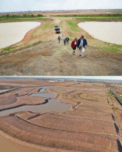
Regional collaboration and flood planning (Top: Ember Group and HCFCD; Bottom: The Grand Prairie in Hockley, TX)
Programs like the Upper Langham Creek and Little Cypress Creek Frontier Programs, also championed by the Harris County Flood Control District, reflect a more intentional and integrated approach to regional watershed planning. Created in response to the rapid development in northwest Harris County, the program combines land use planning, floodplain management, and infrastructure design into a single, coordinated effort across public and private sectors. By mapping out a regional stormwater detention system and identifying strategic sites in advance, the program reduces downstream flood risks while enabling orderly growth. It also serves as a replicable model for other rapidly urbanizing areas, where stormwater infrastructure often lags behind development. With an estimated 20 miles of channel improvements and over two dozen regional basins planned, it exemplifies what’s possible when engineering, planning, and policy align.
In Fort Bend County, the Fort Bend County Drainage District (FBCDD) has embraced a collaborative approach to flood risk management, recognizing that regional problems demand regional solutions. FBCDD regularly partners with municipalities, county departments, levee improvement districts, and regional planning organizations to co-develop solutions that serve both local and downstream interests. Their emphasis on transparent coordination and shared responsibility has made them a key player in several successful infrastructure projects. For instance, FBCDD has worked closely with the Fort Bend County Engineering Department and the City of Sugar Land on detention expansion and storm sewer upgrades, including projects that span both incorporated and unincorporated areas. The Drainage District has also contributed to broader watershed planning efforts that recognize how upstream improvements can support downstream resilience—a critical theme as suburban growth expands into more flood-prone terrain.
Similarly, the Brookshire-Katy Drainage District (BKDD) serves as a vital bridge between Harris, Fort Bend, and Waller Counties—jurisdictions that share both watersheds and development pressure. BKDD has focused its efforts on facilitating cooperation among local governments and utility districts to address growing runoff volumes and aging infrastructure. A key component of BKDD’s work has been to encourage standardized criteria for drainage improvements across jurisdictional lines, reducing the risk of mismatched design standards that can worsen flooding. Over the last few years, BKDD has made significant progress in formulating a master drainage plan that serves to benefit multiple watersheds across county lines. Particularly, collaboration with existing and developing MUD’s, developers, and cities/counties has promoted regional drainage improvements and developments designed with a more flood resilient focus. Additionally, BKDD has emphasized communication, efficiency, and transparency with its permitting process through the implementation of the BKDD Portal.
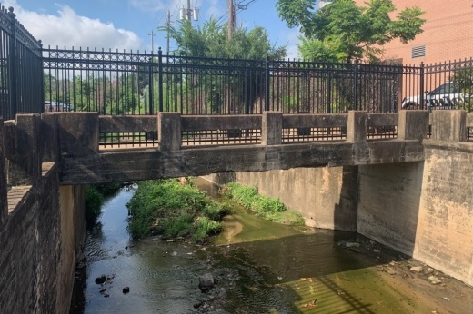
Poor Farm Ditch, a human-made ditch constructed in the 1950’s, runs through The City of Southside Place and West University to successfully help with drainage
Innovative approaches are not limited to the private sector. Local governments working together—what some call “public-public-public” partnerships—are increasingly playing a pivotal role. The City of Southside Place, for instance, leveraged initial bond funding from the 2018 Harris County Flood Control Program to secure over $30 million in additional state and federal support for the Poor Farm Ditch Project. That success came from early engagement with elected officials at every level, including working with Congresswoman Lizzie Fletcher and State Senators Joan Huffman and John Whitmire. Mayor Andy Chan emphasized how essential it was to have a unified message and strong community engagement from the outset. That alignment ultimately helped them avoid late-session funding pitfalls and ensure the project could move into construction by 2025.
Funding remains one of the most significant challenges in delivering flood mitigation infrastructure. Traditional mechanisms like bonds and general revenue allocations often fall short of what is needed for major projects, especially when accounting for long-term operations and maintenance. Creative funding strategies—such as interlocal cost-sharing, public-private partnerships, and special-purpose entities like resilience districts—are helping to bridge that gap. These structures offer more flexibility and often better align with the timing and scale of regional needs.
Maintenance, too, deserves greater attention. Building detention basins, channels, or levees is only the beginning. These systems must be inspected, cleared, repaired, and adapted as conditions evolve. In one instance, the City of Houston partnered with Shell to acquire land near the Willow Waterhole detention system. Shell transferred the land at minimal cost, allowing the City to expand its flood capacity while offsetting expenses through the sale of a portion of the property. These types of arrangements demonstrate how even modest partnerships can deliver long-term value if they include provisions for stewardship and upkeep.
As technology advances, data and modeling are playing an increasingly important role in how we approach flood risk. From real-time sensors to high-resolution hydrologic models, agencies now have tools that allow them to identify problems before they become emergencies. Shared modeling environments also enable different jurisdictions to plan together, ensuring that upstream development doesn’t undermine downstream capacity. That kind of coordination isn’t just efficient—it’s equitable.
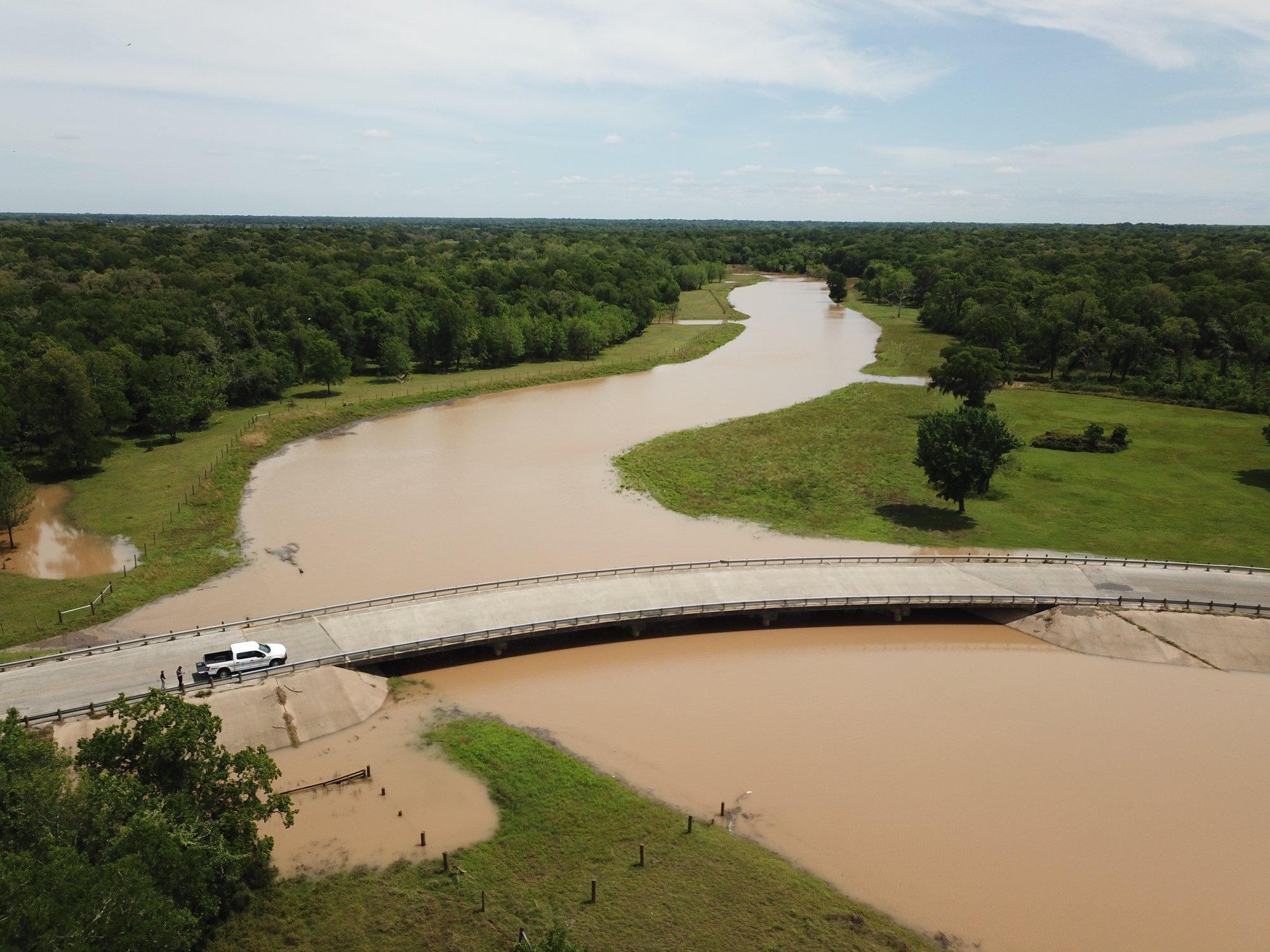
Monitoring flooding along the Brazos River in Fort Bend County
Another key challenge is ensuring that successful efforts are scalable. A project that works in one part of the region may not apply directly to another due to differences in land use, topography, or governance. Still, the principles that make a project successful—such as early stakeholder engagement, transparent cost-sharing, or integrating green infrastructure—are often replicable. As growth continues to push westward into areas like Fort Bend and Waller counties, having a toolbox of proven models becomes increasingly important. These areas are facing pressure to build quickly while still preserving flood resilience, and learning from successes elsewhere can help accelerate their progress.
Achieving this level of regional alignment requires leadership and vision. It involves convening stakeholders who may not always agree, maintaining focus through lengthy project cycles, and keeping community needs at the forefront. Advocacy and coordination play a critical role, as does the ability to navigate state and federal funding systems. For example, when pursuing FEMA support for additional gates at the Lake Houston Dam, project leaders had to revise designs multiple times to meet strict benefit-cost criteria. That process required sustained legislative advocacy and nimble adjustment of statutory language to ensure funds could be used efficiently.
The recent launch of the State Flood Plan by the Texas Water Development Board has underscored just how much work remains. With over $50 billion in identified needs, and only a fraction funded through recent legislative sessions, Texas faces a long road ahead. But the momentum is building—and Houston’s regional leadership is well-positioned to help shape the way forward.
Resilience doesn’t happen by accident. It requires the alignment of technical expertise, political will, public investment, and private ingenuity. The region must continue to explore new models for collaboration, invest in scalable and maintainable infrastructure, and stay ahead of evolving climate and development patterns.
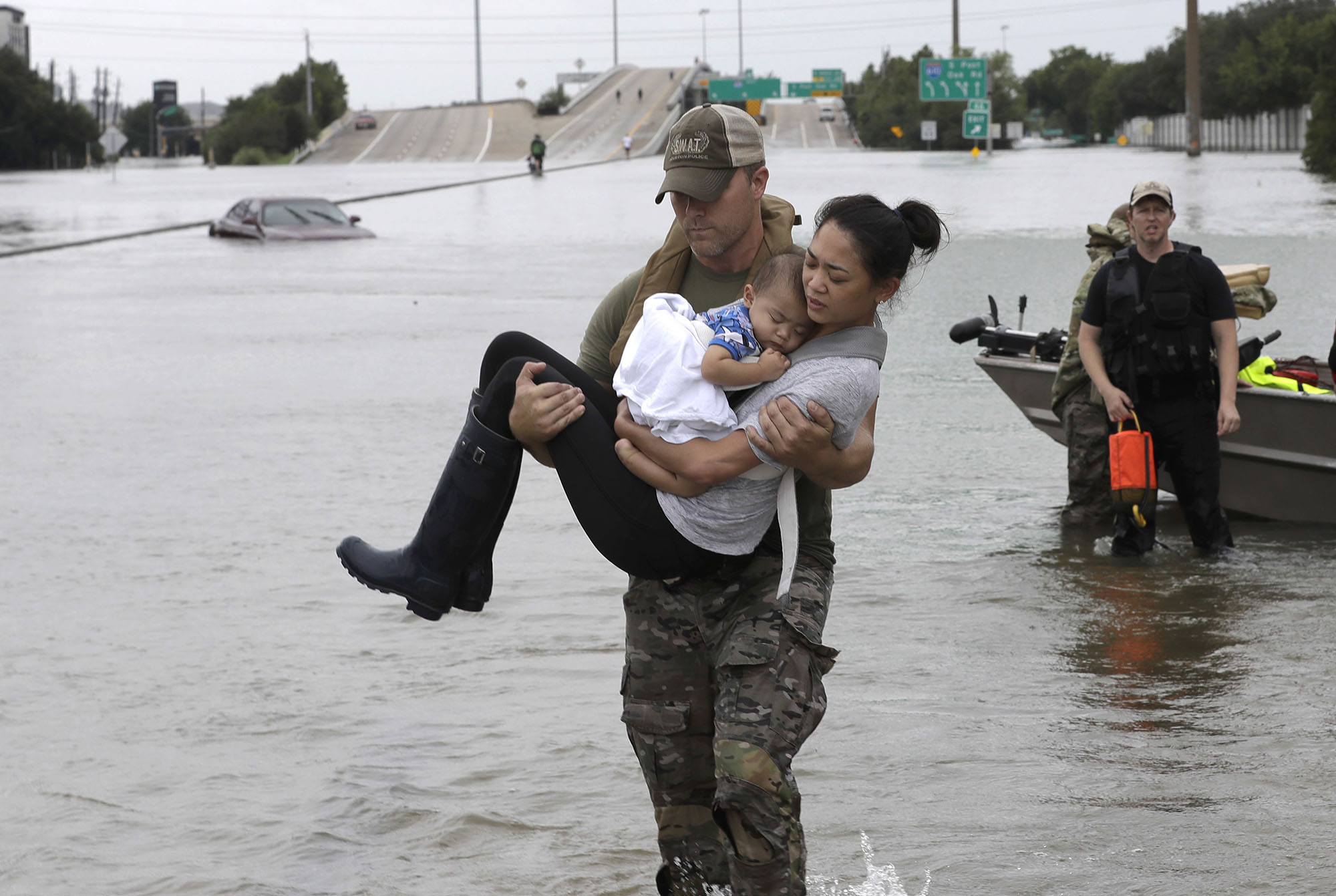
Impacts of flooding (Hurricane Harvey, 2017)
We don’t have to wait for the next flood to act. Across Greater Houston, intergovernmental teams are already demonstrating what is possible when we work together. Their efforts offer a roadmap not just for what can be done—but for what must be done.
Flood control touches everything: housing, transportation, education, economic opportunity, and quality of life. It deserves our full attention and creativity. Now is the time to lean into partnerships, reimagine funding, and put proven models into practice. The future of our region depends on it.
Let’s not settle for simply recovering from floods. Let’s build a region that is prepared, resilient, and stronger than ever.